What is it?
The Kungsleden trail is about 440km in total. This blog includes some general information that might be useful to someone preparing for it. However if you are thinking of doing the entire trail as a through hike then there will be some significant logistical issues to deal with as regards food resupply. We don't tackle those here other than to suppose that breaking the trail up into sections and dealing with each separately would help in this regard. As would a large budget. This blog deals with the northernmost section.
How long did it take?
We walked from Abisko to Vakkotavare (about 160km) between the 8th and 18th of August 2017. We added a side trip to summit Kebnekaise (Sweden's highest mountain) as an optional (but highly recommended) bonus. I was only given the tip to do this directly from the trail (via a cairned route not the main tourist trail) when I was already on the journey. It made much more sense and made the trek fit nicely into the time we had. While we wished we could have stayed longer in fact we had plenty of time to do what we set out to do.
What can I expect?
In terms of landscape it is beautiful, pristine, awesome and severe rather than sharp and dramatic. The drama comes with the weather and the ever changing light.
The route is fairly flat with gentle rises and descents. It largely follows a couple of wide U-shaped river valleys. This is a landscape sculpted by glaciers. There are hanging valleys on all sides.
There is nothing technically difficult in summer conditions. Winter may be another matter entirely. The track is very easy to follow. There are no difficult river crossings (with the water at the levels we encountered - YMMV). There's lots of boardwalk on the boggier sections.
There is not a great deal of wildlife. We saw quite a few reindeer in herds on a couple of occasions. Not many birds but several people we saw carried binoculars. Maybe they spent the time to see more. To make up for this there are lots of mosquitoes. These are more prevalent in the lower areas where there are trees. Generally in the middle section we weren't much troubled by them.
How far in one day?
If you are carrying all your food then you'll probably be going slowly and some sections are rocky which is also a bit slower. As a rule of thumb you could say 2.5km per hour is a good "planning speed" for the first four days. After that you might plan on 3-3.5km per hour. So a 15km day might comprise 6 hours walking with say two hours of breaks. That's a 9-5 job. Plenty of time (and essentially unlimited daylight) to set up camp and enjoy the evening. Nearer the end that same day might cover 20km.
We took 11 hours on the summit day carrying only light daypacks. (5 up, 5 down with an hour near the summit). This was going gently but steadily with few breaks. We did take an hour long break after the summit. It's not really necessary to leave very early. After all it's not going to get dark. Mostly it'll depend on luck as to when in the day it is calm, or clear, or windy, or raining/snowing.
Why go?
One of the chief delights is the sense of being so far away from the rest of the world. A total lack of phone signal helps a lot here. Going slowly becomes something to savour and enjoy. And it puts off the evil day of arriving at the end. It is immensely refreshing to spend a period where the only people you encounter are also hikers (including canine ones) and where all communication is done face to face. Your ability to set up camp and cook in testing conditions will inevitably mature during the course of the trek, and thus your comfort zone expands.
In summary
It's tougher than it looks on paper, but also more deeply rewarding. If you feel like "stop the world, I want to get off", then this is as good a place to get off as any.
Thursday, 31 August 2017
Wednesday, 30 August 2017
Download
Click here to download a zipped bundle of files (3.7Mb) containing:
1. Jpeg image of the map
2. PDF document of the map
3. KML file of the map
4. KML file of the route
1. Jpeg image of the map
2. PDF document of the map
3. KML file of the map
4. KML file of the route
Clothing
Conditions
As mentioned in the Hazards section the weather is highly variable. This requires flexibility, fine adjustments and appropriate packing.
I constantly try and maintain an even temperature so that I am warm enough to be comfortable but cool enough not to sweat. When clothes drying is potentially limited this latter is especially important. Also to save weight you may not have much to change into.
I kept my rain gear at the very top (under the lid) at all times when it wasn't being worn. I usually have a light fleece beanie and a buff in a handy pocket as nothing helps control temperature like getting your head gear right.
I only wore the down jacket around camp, and even then was careful to keep it dry. Fleece layers are less susceptible to moisture and the thick fleece with a hood was an especially good choice on this trek.
Layers
Lots of layers is the answer. Preferably starting with an Icebreaker merino base layer that never comes off outside Stockholm. That's actually better than it may sound.
Upper body
Icebreaker long sleeved zip top
Sherpa Trekking T shirt
Sherpa light fleece top
Sherpa heavy weight hooded fleece top
Mont Bell Down jacket with hood
OR (Outdoor Research) Goretex Pro shell jacket
Lower body
Marks and Spencer lightweight quick drying briefs
Quechua stretch trekking shorts (I really like these and cycle in them too)
Sherpa trek pants
OR Goretex Pro Alpine pants with full zip legs
Often I wore all four lower body layers. It was comfortable and warm, but that's a lot of zips when you're in a hurry.
Extremities
Quechua trekking cap
Quechua light fleece beanie
Outdoor Designs windstopper fleece hat
4 buffs (1 of them a polar buff)
Quechua silk gloves
Lightweight fleece gloves (lent to my companion)
Extremities Goretex mitts with heavy duty fleece liners
That last item seemed overkill when packing back in May, until it saved me from frostbite on the summit. My hands were warm, dry and comfortable in these monsters. Well worth it.
Tuesday, 29 August 2017
Footwear
Socks
I took six pairs of socks. Three were Quechua lightweight ankle socks. Three were wool (1 Quechua and two heavier Bridgedale ones). The latter were expensive but are starting to prove better value than cheaper ones. Still going strong after 5 years.
I'd go with more wool and less lightweight ones next time. But I'm constrained by what I have for the bike trip. In an ideal world I'd keep two pairs dry for night time use (2x5 days and 4x3 day's for the others). All the others will get wet. You may or may not be able to dry then. Recommend double sealing used socks in zip lock bags and hope they don't escape before you can launder them.
Shoes
I wore Salomon X-Ultra NON Goretex shoes with Superfeet green inner soles. These were fine for the conditions EXCEPT on the ice on the summit. That was a very short but rather sketchy section. Otherwise very good.
I wore Salomon X-Ultra NON Goretex shoes with Superfeet green inner soles. These were fine for the conditions EXCEPT on the ice on the summit. That was a very short but rather sketchy section. Otherwise very good.
That said, most people I saw wore boots. And probably had wetter feet for longer as a result. But they probably felt comfortable and secure in familiar footwear, so each to their own. The exceptions to this were the odd ultralight hiker and some mountain runners. They also used Salomons.
I mostly did river crossings in bare feet unless I could easily rock hop across. The water was cold but frankly after Iceland it seemed pretty mild. That's the benefit of having one's comfort zone stretched a bit. Still it was way too cold to even consider bathing.
Wednesday, 23 August 2017
Food
Aside from being a very personal choice, the food you will need depends on your style of doing this walk, of which there are several. While it is probably possible on this northern section to opt entirely for staying and eating in huts, for many people this would be difficult financially, despite the evident appeal of comfort and convenience.
We did the entire walk unsupported, carrying and cooking our own food. We carried a bit too much for a few reasons. Firstly, I prefer to err on the side of caution, especially in unknown climates; the colder it gets the more I eat. Secondly, we had relatively little time together before the trip to really go through what we had got collectively. And thirdly my food dehydration and repackaging project is still in the future.
Still with the benefit of hindsight this is what we might have carried. It should be also noted that I have a relatively high capacity for repetitive menus on the basis that "food is just fuel". However in contradiction to that assertion I must mention that for me Chai is an essential and quite a bit of weight was dedicated to ensure a liberal supply.
Packaging
Packaging, or rather repackaging, is important for three reasons: weight, volume and convenience, and this trek provided a good opportunity to reflect on this process.
There are a number of ways of organising one's food: randomly, in bulk, by meal type, or by menu. Obviously the first thing to do is remove all unnecessary packing (perhaps it's useful to take a photo first of any cooking instructions with which one is unfamiliar). Also if you are doing this at home it is helpful to have a digital scale to check weights, so you are sure of exactly what you have. Labelling is also good. Bulgur makes a poor substitute for cane sugar, but admittedly better than salt for white sugar.
I have for a while repackaged food in ziplock bags by meal type and have a dry bag for breakfast, lunch, dinner, snacks and drinks. This way I can ensure that lunch and drinks are on top when I pack my single compartment sack in the morning. In an ideal world there is everything one needs for a given meal in one pack, but then there are things like salt and pepper or milk powder which may be used across multiple meals.
A slight modification to this regime occurs with snacks (I put the day's ration into a convenient pocket) and for Chai where I have a bulk supply bag and a "next few days" bag. The latter uses more convenient small screw top plastic jars, which are much easier to open and reseal with powders. This imposes a small volume penalty but if they are topped up regularly this is minimal.
On the whole this worked pretty well and certainly helped with stashing and finding things in the tent.
However I am not convinced that this system is optimal from a time point of view, and have been thinking about building single day food packs as part of a broader project to move to more self-dehydrated food. Rationing supplies becomes a lot easier and the current day's bag is always packed at the top. Basically this is transferring some of the organisational time to a period before the trek, but this is quite efficient as one could pack many day packs in just a few hours. After that packing for a trek of X days becomes very simple, and at the same time more variety can be built in - assuming you have labelled the contents.
The cost may come in slightly increased numbers of bags, but as these would be used over again it results in less waste. A nice innovation would be if the packaging itself were edible, or perhaps some could be waxed paper which might be burned safely. Looking at the waste that we produced over 11 days all of it was food related; 90% was packaging and the balance was composed of the empty gas canisters and a few baby wipes.
Further time savings on the trail could be achieved by having most meals pre-cooked and then dehydrated and packaged into meal-sized packs. And while it is nice to sit and prepare an evening meal together with someone under good conditions, there certainly are moments when you would much rather just get a good meal down and go to sleep. Just boiling water and adding to a bag also cuts down on washing up, which is always a good thing.
Breakfast: Oats (800g), Muesli** (250g), Raisins (500g), Milk Powder
Lunch: Bread (125g/day), Cheese (100g/day), Jam (in plastic tub 200g) Packets of soup (1 per 2 days)
Dinner: Rice (125g/day) or mixed grains (200g/day) or Bulgur (125g/day) or Pastas (150g/day), Red Lentils (500g), Salt, Pepper, Olive Oil (250ml), Spices, Tomato concentrate (3 x 200g tubes), garlic (3 bulbs)
Snacks: Muesli bars (16), Chocolate (300g), Dried Fruit (2x250g)
Drinks (for TWO): Tea bags (85), Milk Powder (1kg), Sugar - cane or raw (1kg), Fresh ginger (300g), Chai spices (100g of own mix), Cocoa (200g)
Other: Baby wipes, Hand sanitiser, Batteries*
* This is for ONE person for 12 days (ten days trek plus two journey days)
** Given the allergies of my companion this was the only item containing nuts.
* There is little need for a headlamp in summer
We did the entire walk unsupported, carrying and cooking our own food. We carried a bit too much for a few reasons. Firstly, I prefer to err on the side of caution, especially in unknown climates; the colder it gets the more I eat. Secondly, we had relatively little time together before the trip to really go through what we had got collectively. And thirdly my food dehydration and repackaging project is still in the future.
Still with the benefit of hindsight this is what we might have carried. It should be also noted that I have a relatively high capacity for repetitive menus on the basis that "food is just fuel". However in contradiction to that assertion I must mention that for me Chai is an essential and quite a bit of weight was dedicated to ensure a liberal supply.
 |
| Another pot of "Kebnekaise stew" is ready |
Packaging, or rather repackaging, is important for three reasons: weight, volume and convenience, and this trek provided a good opportunity to reflect on this process.
There are a number of ways of organising one's food: randomly, in bulk, by meal type, or by menu. Obviously the first thing to do is remove all unnecessary packing (perhaps it's useful to take a photo first of any cooking instructions with which one is unfamiliar). Also if you are doing this at home it is helpful to have a digital scale to check weights, so you are sure of exactly what you have. Labelling is also good. Bulgur makes a poor substitute for cane sugar, but admittedly better than salt for white sugar.
I have for a while repackaged food in ziplock bags by meal type and have a dry bag for breakfast, lunch, dinner, snacks and drinks. This way I can ensure that lunch and drinks are on top when I pack my single compartment sack in the morning. In an ideal world there is everything one needs for a given meal in one pack, but then there are things like salt and pepper or milk powder which may be used across multiple meals.
A slight modification to this regime occurs with snacks (I put the day's ration into a convenient pocket) and for Chai where I have a bulk supply bag and a "next few days" bag. The latter uses more convenient small screw top plastic jars, which are much easier to open and reseal with powders. This imposes a small volume penalty but if they are topped up regularly this is minimal.
On the whole this worked pretty well and certainly helped with stashing and finding things in the tent.
However I am not convinced that this system is optimal from a time point of view, and have been thinking about building single day food packs as part of a broader project to move to more self-dehydrated food. Rationing supplies becomes a lot easier and the current day's bag is always packed at the top. Basically this is transferring some of the organisational time to a period before the trek, but this is quite efficient as one could pack many day packs in just a few hours. After that packing for a trek of X days becomes very simple, and at the same time more variety can be built in - assuming you have labelled the contents.
The cost may come in slightly increased numbers of bags, but as these would be used over again it results in less waste. A nice innovation would be if the packaging itself were edible, or perhaps some could be waxed paper which might be burned safely. Looking at the waste that we produced over 11 days all of it was food related; 90% was packaging and the balance was composed of the empty gas canisters and a few baby wipes.
Further time savings on the trail could be achieved by having most meals pre-cooked and then dehydrated and packaged into meal-sized packs. And while it is nice to sit and prepare an evening meal together with someone under good conditions, there certainly are moments when you would much rather just get a good meal down and go to sleep. Just boiling water and adding to a bag also cuts down on washing up, which is always a good thing.
Shopping Check List*
Lunch: Bread (125g/day), Cheese (100g/day), Jam (in plastic tub 200g) Packets of soup (1 per 2 days)
Dinner: Rice (125g/day) or mixed grains (200g/day) or Bulgur (125g/day) or Pastas (150g/day), Red Lentils (500g), Salt, Pepper, Olive Oil (250ml), Spices, Tomato concentrate (3 x 200g tubes), garlic (3 bulbs)
Snacks: Muesli bars (16), Chocolate (300g), Dried Fruit (2x250g)
Drinks (for TWO): Tea bags (85), Milk Powder (1kg), Sugar - cane or raw (1kg), Fresh ginger (300g), Chai spices (100g of own mix), Cocoa (200g)
Other: Baby wipes, Hand sanitiser, Batteries*
* This is for ONE person for 12 days (ten days trek plus two journey days)
** Given the allergies of my companion this was the only item containing nuts.
* There is little need for a headlamp in summer
Photos
Just a few hints. There is plenty to see elsewhere, but personally I prefer to come at it unencumbered by too many images.
 |
| Day 1: First view of the Arctic from the train |
 |
| Day 1: Map of Abisko National Park. Note the shelter at Nissonjohka |
 |
| Day 1: The first stretch is along this magnificent river |
 |
| Day 2: Boardwalk empire |
 |
| Day 3: Campsite in the early morning |
 |
| Day 3: Approaching Alesjaure lake |
 |
| Day 3: Leaving Alesjaure lake |
 |
| Day 4: The trail is very easy to follow |
 |
| Day 5: The view from camp for two nights |
 |
| Day 6: Above the col on the way up Kebnekaise |
 |
| Day 6: This shelter is a short distance from the summit |
 |
| Day 6: The clouds parted as we descended |
 |
| Day 6: Our camp comes into view at the end of a long day |
 |
| Day 7:A windy pitch a short distance off the trail |
 |
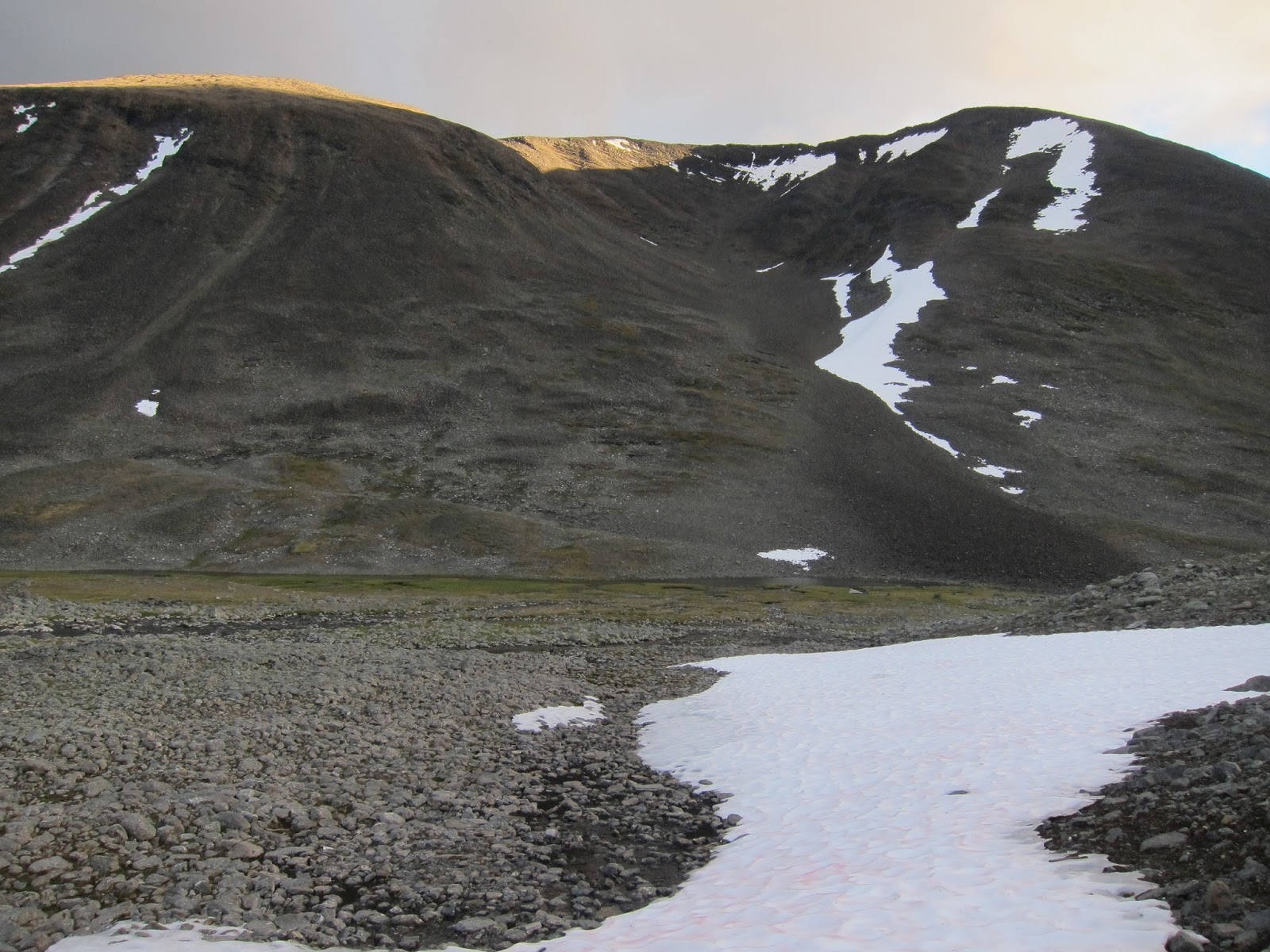
| Day 8: Looking back up the valley |
 |
| Day 8: There were several waterfalls on this stretch |
 |
| Day 8: The bridge shortly before Kaitumjaure Hut |
 |
| Day 9: After the rain |
 |
| Day 10: The fire is more against mosquitoes than for warmth |
 |
| Day 10: View from the camp site |
 |
| Day 11: The end of the trail |
Map

The route follows the Kungsleden track as shown in OpenStreetMap.
Note! This is not a recorded GPS track, but was created using Graphhopper, saved as a GPX file then converted to KML using GPS Visualizer.
The places we camped were recorded by us close to (or indeed from inside) our tent.
Subscribe to:
Posts (Atom)